Postingan

Menampilkan postingan dari Agustus, 2019

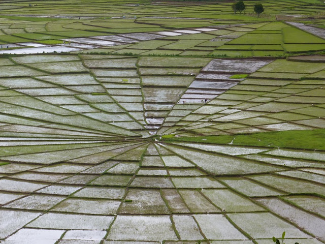
CANCAR SPIDER RICE FIELDS
Gambar
CANCAR SPIDER RICE FIELDS In Manggarai you will certainly notice the impressive  lingko  fields. The most amazing view over a number of these fields is offered at Cara Village situated on a small hill 17km west of Ruteng in Cancar. With their round, spider-web structure, these pieces of land are unique eye-catchers in Manggarai. Long before wet-rice cultivation, the ancestors of the Manggaraian people grew dry rice, corn, and tubers in the lingko fields. Every village used to own several fields. During planting and harvesting time, ceremonies and ritual offerings were held at the lodok, the ritual center of the lingko. The lodok features a wooden pole and a rock. These two objects symbolize the reunion of the male and female, the heaven and earth, and the creation of mankind. If a new lingko was developed, the sacrifice of a water buffalo was required. The division of a new lingko was guided by the tu’a teno, the Lord of the Land. This traditional leader ha...

WATUBLAPI IKAT WEAVING

Gambar
WATUBLAPI IKAT WEAVING Watublapi is a small community in the Sikka district well known for its fine traditional ikat weaving. Whereas many other local weaving communities switched to industrially spun yarn and chemical dyes for the sake of saving time and money, the weavers of Watublapi still use the traditional, handspun yarn made out of local cotton, as well as local natural dyes. In the 1980s, the villagers – along with the assistance of the German priest, Pater Bollen – established a cultural cooperative called Sanggar Bliran Sina with the goal of preserving and promoting local dance, music, ikat weaving, and other handicrafts. Under the enthusiastic leadership of Daniel David, a young man from Watublapi, Bliran Sina has turned into a well-established cooperative of more than 40 members, who support each other in financial, educational, and health issues. Furthermore, Bliran Sina’s outside orientation and collaboration with Fair Trade organizations, such as Threads o...

Semana Santa

Gambar
SEMANA SANTA Each year, Larantuka celebrates the Holy week known as ‘Semana Santa’. It is held during the week before Easter Sunday. All along the Holy week, Catholic pilgrims from Flores and all over Indonesia flooded the tranquil city of Larantuka. The prayers center around two religious icons. They are the statue of Jesus Christ (locally known as Tuan Ana), and the Virgin Mary (Localy known as Tuan Ma). The statues were brought to Larantuka by Portuguese missionaries Gaspar do Espírito Santo and Agostinho de Madalena in the 16th century. These statues are presented to the public only during Easter and are kept out-of-view for the rest of the year. The procession of Semana Santa begins with Rabu Trewa or the Shackled Wednesday, which devotees gather to pray in the chapel, remembering the betrayal of Jesus by Judas Iscariot. It is the time mourning; a time when it drowns into solemnity and reflection for the purification of the soul. Followed by Maundy Thursday, devot...

RIUNG 17 ISLANDS

Gambar
RIUNG 17 ISLANDS The sub-district of Riung, located to the north of Bajawa, is famed for its beautiful coral gardens. The coast and the surrounding area of the town of Riung have become a national conservation area, and were even given the status of a national park and named Pulau Tujuh Belas, or ‘Seventeen Islands’. In fact, the national park consists of more than 20 small and larger islands. The local people, though, have named the area ‘Riung Seventeen Islands’, a label that is easy to remember as it refers to the personification of a beautiful 17-year-old girl and also Indonesian Independence Day on the 17th of August. Island life The national park area is inhabited by various exotic species, e.g. the Timor deer, hedgehogs, monkeys, ferrets, the Timor monitor lizard, marsupials, and partridges. The large variety of birds, such as eagles, white herons, black storks, partridges etc, make the area a great spot for bird watching. Even a moderate-sized species of a K...

Three Colour Lakes

Gambar
KELIMUTU NATIONAL PARK Mount Kelimutu, with its tri-colored crater lakes, is probably the most amazing natural phenomenon in Flores. Beyond that, the ‘steaming mountain’ is also the island’s most famous tempat angker, or mystical, haunted place. Scientific explanations aside, there are many myths about the origin of Kelimutu. This is one of the reasons why Mount Kelimutu was, and still is a sacred place for the local people. Over the years, the three crater lakes have often changed color. At present, one of the lakes is black-brown, one is green, and one is currently changing from green to a reddish color. A reason may be the varying mineral contents of the water. Another explanation suggests that the changing colors are caused by the neglected ancestral souls. The first lake is named Tiwu Ata Mbupu (lake of the ancestors’ souls ); the second is named Tiwu Nuwa Muri Koo Fai (lake of young people’s souls); and the third is called Tiwu Ata Polo (lake of evil spirits). T...

TODO VILLAGE

Gambar
TODO VILLAGE The village of Todo in south-central Manggarai is not only one of the few opportunities to see the traditional ceremonial houses; in the past, Todo was also the center of the Manggaraian kingdom and the home of the royal clan. The clan of Todo had been the dominant power in southern Manggarai long before the Dutch administration started to get involved in local politics. The clan leader was chosen to be King of Manggarai by the Dutch colonial government in 1930. The members of the clan claim that their ancestors came from Minangkabau in Sumatra hundreds of years ago, with a leader named Mashur. There are many legends about the long journey of these travelers before they presumably entered Manggarai in  Warloka .  From there, Mashur and his people started a long myth-bound journey through Manggarai, before finally settling down in Todo. As Mashur took a wife from every village that he and his companions passed, the Todo clan now claims an extensive ...

Benna Village and How to get there

Gambar
BENA VILLAGE Bena, a community that is situated about 16km from Bajawa at the foot of Mount Inerie, is the most famous and also most visited village in the Ngada district. With its impressive stone formations and ancestral shrines, as well as traditional houses, Bena has turned into a signpost for Ngada culture. The village consists of two parallel rows of traditional, high thatch-roofed houses. Highly visible in the center of the village are ngadhu and bhaga, pairs of shrines – one for each clan of the village – representing the clan’s ancestors. The ngadhu is an anthropomorphic umbrella-like pole embodying the male ancestor of a clan. The trunk is decorated with carvings and is topped with a warrior-like figure. The ngadhu symbolizes fierceness and virility. After a new ngadhu has been carved out of a special tree, the men of the village carry the pole in a ceremonial way into the village. The bhaga, a female ancestral clan shrine, is a small hut with a thatched...

komodo giant lizard

Gambar
KOMODO NATIONAL PARK Komodo National Park, located between Sumbawa and Flores, was founded in 1980 with the aim of protecting the endangered Komodo dragon. As the park is not only the last sanctuary for the Komodo dragon but also a unique area of marine biodiversity, it became a Man and Biosphere Reserve in 1986 and entered the list of UNESCO’s World Heritage Sites in 1991. With its outstanding submarine richness, it is not surprising that the park is one of the world’s finest destinations for scuba divers. With an area of 1,817 km², the park consists of Komodo Island, Rinca Island, Padar Island, and numerous smaller islands. The famous giant lizards, who are unique to Komodo National Park, are not only of great interest to tourists but also to scientists studying the theory of evolution. Rinca Island Inhabitants Komodo National Park is home to about 3,500 people who live in four villages. The largest settlement is Komodo Village on Komodo Island; the other settlemen...